


Geodesy
Description of Geodesy
Geodesy is an application designed for geographic calculations, available for the Android platform. This app offers a range of tools tailored for surveyors, engineers, navigators, and students of geodesy, providing an intuitive interface to facilitate various geospatial tasks. Users can download Geodesy to access its broad functionality which includes coordinate conversion, area measurement, distance calculation, and more.
One of the primary features of Geodesy is its coordinate conversion tool. This tool allows users to convert between several formats, including Degrees, Degrees/Minutes, Degrees/Minutes/Seconds, UTM, MGRS, and Maidenhead. The inclusion of error checking ensures that users can trust the accuracy of their conversions, making this a reliable resource for professionals in the field.
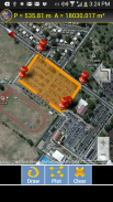
Another significant functionality of the app is its ability to draw free-form closed shapes on maps. Users can plot points to determine the perimeter and calculate the enclosed area. This feature is particularly useful for tasks such as construction planning or gardening, where precise area measurements are necessary. Whether users want to measure their backyard or assess larger land areas, this tool provides easy and accurate results.
Geodesy also enables users to plot two points on a map, presenting altitudes as well as the distance and altitude difference between them. In addition, the app provides reverse geocoded locality information, allowing users to gain geographic context for their selected points. This feature is beneficial for navigation and understanding the terrain between various locations.
For those engaged in technical calculations, Geodesy includes solutions for both the direct and indirect geodetic problem. Users can select their desired geoid or datum, making the app suitable for a variety of geodetic applications. The availability of a geodetic problem calculator allows users to solve inverse and direct geodetic problems efficiently.
Distance calculations are another integral aspect of Geodesy. Users can determine the distance from their current position to any location on the globe. This feature is valuable for navigation and planning purposes, providing insights into travel distances and routes.
Magnetic field tools are also incorporated within the app, including a compass that features a magnetic declination indicator. This tool aids users in understanding the earth's magnetic field and how it may influence navigation and orientation, making it a practical addition for outdoor activities.
Time measurement capabilities are included as well, offering users the ability to track and record time-related data as they engage in their geographic investigations. This feature can help in planning and executing various tasks that require precise timing.
Documentation and support are robust within Geodesy, providing users with easy-to-follow help guides and resources. This ensures that both new and experienced users can navigate the app's features effectively, enhancing their overall experience.
The app is designed to cater to a diverse user base, including professionals and students, who require efficient tools for geographic analysis. With its range of features, Geodesy stands out as a versatile application for anyone involved in geodesy or related fields. Users seeking to enhance their geographic calculations can download Geodesy and take advantage of its comprehensive tools.
The combination of tools for coordinate conversion, area measurement, distance calculation, and geodetic problem-solving makes Geodesy a valuable resource. Whether for academic purposes, professional projects, or personal interests, the app offers functionalities that cater to a wide array of geographic tasks. Its user-friendly interface and detailed documentation further contribute to a seamless experience for all users.
Geodesy provides a comprehensive suite of features that facilitate geographic calculations, making it a useful application for anyone working within this field. The emphasis on accuracy, usability, and a variety of tools ensures that users can effectively carry out their tasks with confidence. The ability to convert coordinates, measure areas, calculate distances, and understand magnetic fields supports a broad spectrum of applications, enhancing the efficiency of geographic analysis.
This app presents a practical solution for those looking to engage with geodesy in various capacities, from casual users to seasoned professionals. Its availability on the Android platform allows for easy access and integration into daily activities related to geographic data analysis and navigation.
Geodesy - APK Information
APK Version: 1.42Package: com.discipleskies.android.geodyseyLatest Version of Geodesy
Other versions


 4.49
4.49


Apps in the same category

You may also like...


